
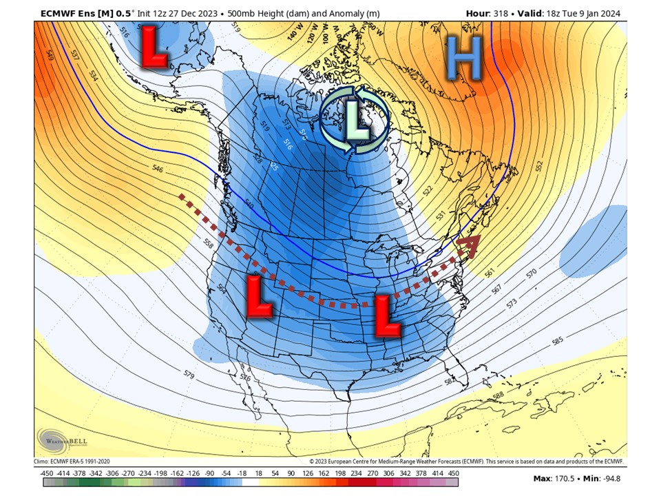
A significant pattern change is in the process of occurring across the Northern Hemisphere, with the effects starting to become visible in the local region at this time. Thus far this season, we have been dealing with consistently mild temperatures, sometimes very mild. This has not only been the case across Illinois but across much of the region and country. Not surprisingly, snow has also been lacking, with significant snowfall deficits compared to average across much of the state, region, and even country. The pattern change that we are settling into, which will most definitely evolve over time, will likely last for at least the next few weeks. This pattern is likely to bring the state closer to normal winter-like conditions on a more consistent basis.
Non-Technical Discussion
It is expected that we will see a consistent flow of waves/disturbances/troughs break off deeper/mean troughing around the Bering Sea/Aleutians down into the Northeast Pacific. These waves/disturbances/troughs will then enter the CONUS along the West Coast, eventually moving across the CONUS. It is possible with time that deeper/mean troughing will develop down into the Western half of the CONUS (-PNA) for a time as we get into the first weekend and second week of January. It should be noted that not every wave/disturbance/trough will bring a storm system that will bring precipitation to the state, but having a constant feed is good to see if you’re looking for at least semi-active weather conditions.
Another thing that will unfold is significant ridging across Central Canada, which is expected to retrograde west into Western Canada, Alaska, and the Beaufort Sea. This will aid in shutting down some of the significant Pacific air influx across the country, which we have been seeing for the past several weeks. Instead, over the next few weeks, air will originate more from the Northeast Pacific and Pole regions. With time, the aforementioned ridging will likely break down, with a vortex lobe potentially becoming established across the heart of Canada as high latitude blocking develops as a result of significant stratospheric warming occurring. As a whole, all of the above will shut off the consistently mild/very mild temperatures and instead return us closer to more seasonable conditions overall. A few brief mild periods still cannot be ruled out, though.
What all of this means is that we will see a pattern that will feature conditions a bit more wintry than we have seen across the state over the past several weeks. Temperatures will be less mild overall and definitely less consistently mild/very mild. With a semi-active pattern setting up with time and with the change in temperatures expected, favorability for wintry precipitation prospects should increase, potentially much more than we have seen thus far this season.


Technical Discussion
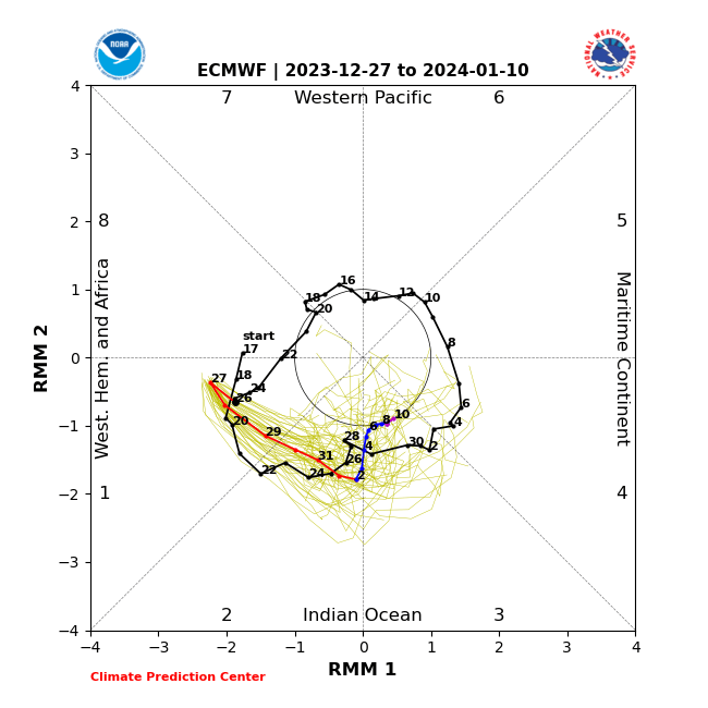
Two big changes that we are seeing right off the bat and that have already begun are a progression of the MJO (Madden-Julian Oscillation) into the colder phases and stratospheric warming. The MJO recently entered the COD (Null forcing) after being in low-amplitude warmer phases from the very end of November through the first 2/3rds of December. The trip through those warmer phases is one of several reasons (Raging Pacific Jet is another) that we have been stuck in a consistently mild (Sometimes very mild) regime. The MJO has now entered colder phases, low to moderate amplitude phases 8–1, and is expected to make a trip at lower to moderate amplitude through colder phases 1-2 over the next week or so. In total, the MJO is expected to have taken a nearly 2-week trip through the colder phases when all is said and done. Another thing that we will be watching unfold is stratospheric warming. This warming is expected to disrupt the main SPV (Stratospheric Polar Vortex) placement and strength during the potentially 2-3-week event. As is usually the case, any effects of a potential SSWE (Sudden Stratospheric Warming Event) will not be seen right away; that is something to keep an eye on from around the first weekend of January/second week in January through early February. There are already signs of high latitude blocking, including a -NAO (Greenland area blocking high), developing in the medium to long range as an effect of the stratospheric warming.

As mentioned above, there are a few reasons we have been seeing consistently mild (Sometimes very mild) conditions over the past several weeks. The raging Pacific jet is one of those bigger reasons. The Pacific jet is in the process of breaking down, with increased troughy-ness (Wave breaks) developing. Canadian ridging, which will retrograde from Central to Western Canada and eventually Alaska/Beaufort Sea, will also tend to lower Pacific influence as well.


Getting beyond the MJO, SSW, and Pac Jet… We are likely to see a fairly consistent flow of waves/disturbances/troughs enter the CONUS along the West Coast, originating from the deep/mean trough from the Bering Sea/Aleutians down into the Northeast Pacific. This is characterized by the lower-height anomalies from the Northeast Pacific and then across the southern 2/3rds or so of the CONUS. It is possible with time that deeper/mean troughing will develop down into the Western half of the CONUS (-PNA) for a time as we get into the first weekend and second week of January. Additionally, with the Pacific jet breaking down, the retrograding ridging in Canada, and a potential vortex lobe taking up residence in Canada eventually, we’ll see generally cooler/colder conditions overall than have been seen, with an airmass origin more often than not from the Northeast Pacific to Pole regions.


In Summary
•While the pattern might not be super/hyper active, there will be a steady stream of waves/disturbances that traverse the CONUS. Will they all turn into something interesting, or will they all bring precipitation to the state? No. But having a feed is good to see.
•It is very clearly not going to be as significantly/consistently as mild as it has been. That’s not to say there won’t be any bouts of mild temperatures, but what we have been seeing the past several weeks will be in the past for now.
•The chances for wintry storm potential are not amazing to start, but may improve around the first weekend in January/the second week of January. Either way, it should be an improvement compared to much of the past 1-2 months, and there will be more opportunities for snow than we have seen in the past month or two.