
(11:00AM – Monday, April 27th, 2026) Severe weather threat continues through later tonight/very early Tuesday morning…
⚠️Update…
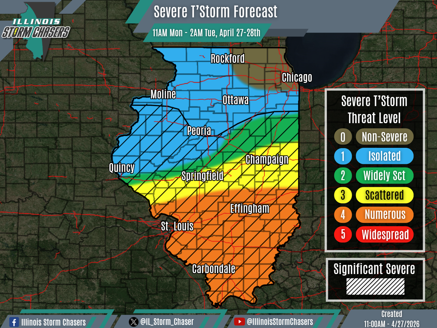
•With this update cycle, on the forecast for today/tonight, we have slightly adjusted severe t’storm probabilities along the gradient across portions of Central Illinois, based on real-time observations and the latest trends. Additionally, we have upgraded all of Southern Illinois to a level 4 severe t’storm threat, to account for the potential of increased severe t’storm coverage. We have also removed the level 1 severe t’storm threat from portions of Northeastern Illinois, where an isolated severe t’storm threat is no longed expected.
⏰📍Timing & Location…
•This Morning – Early Tuesday Morning, April 27-28th: All of Illinois.
⚡️Hazards…
•A level 1 to 4 severe t’storm threat is in place across much of the state from this morning through early Tuesday morning, for the threat of isolated to numerous severe t’storms. All modes of severe weather will be likely, including large hail, damaging winds and a few/several tornadoes. Some significant severe t’storms will be possible as well across a large portion of the state as well, capable of producing very large hail (2.00″+), significant damaging winds (75MPH+), swaths/corridors of damaging winds and/or strong tornadoes.
✔️Summary…
•This Morning – Early Tuesday Morning… Two separate complexes (MCS’s) of rain and t’storm activity have been traversing the state from overnight and into this morning. The latter MCS continues to track across a large portion of the state this morning, and is accompanied by severe t’storm activity across Central Illinois. This MCS will continue to track eastward across the state into the afternoon, with a continued severe t’storm threat across especially Central Illinois. In the wake of this activity and south of this activity, some atmospheric recovery is expected to occur, setting the stage for another round of shower and t’storms to develop on this afternoon across Eastern Missouri and Western/Southwestern Illinois, along and ahead of an advancing cold front and along an outflow boundary from earlier day activity. This activity will then sweep eastward across portions of Central and all of Southern Illinois, posing a severe t’storm threat from this afternoon into later tonight/early Tuesday morning. Additionally, some isolated to widely scattered shower/t’storm activity may also try to re-develop further north, across Eastern Iowa and Northwestern Illinois, then moving across portions of Northern Illinois. However, the severe t’storm threat further north is expected to be lower overall (coverage and severity), due to less expected recovery in the wake of earlier day activity.
