
(11:45AM – Tuesday, April 14th, 2026) Multi-day severe weather threat continues through early Thursday…
⚠️Update…
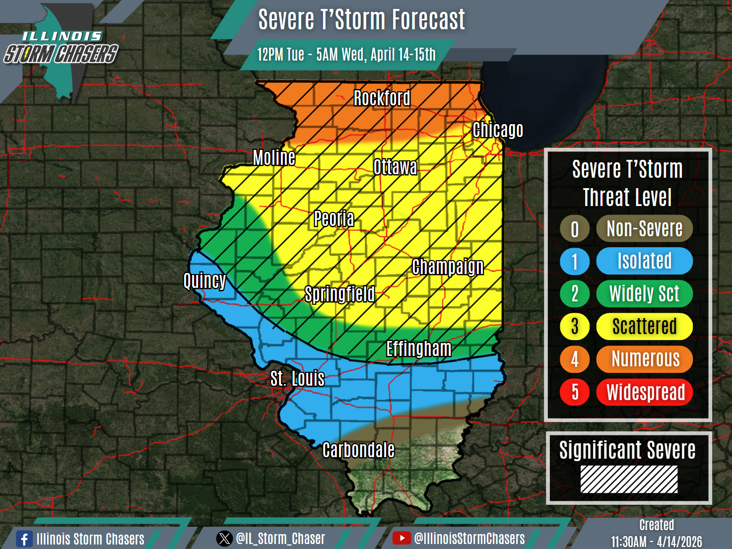
•With this update cycle, on the forecast for today/tonight, we have expanded level 3 severe t’storm probabilities across more of Northern and Central Illinois. Additionally, we have upgraded portions of Northern Illinois to a level 4 severe t’storm threat. These changes are based on trends and real time observations, leading to higher confidence in higher coverage severe t’storm potential.
•With this update cycle, no changes were needed to the going forecast for Wednesday/Wednesday night.
⏰📍Timing & Location…
•This Afternoon – Early Wednesday Morning, April 14-15th: Northern & Central Illinois.
•Wednesday Morning – Early Thursday Morning, April 15-16th: Much of Illinois.
⚡️Hazards…
•A level 1 to 4 severe t’storm threat is in place across Northern and Central Illinois from this afternoon through early Wednesday morning, for the threat of isolated to numerous severe t’storms. All modes of severe weather will be likely, including large hail, damaging winds and a few/several tornadoes. Some significant severe t’storms will be likely across Northern and Central Illinois as well, capable of producing very large hail (2.00″+), significant damaging winds (75MPH+) and/or strong tornadoes.
•A level 1 severe t’storm threat is in place across much of Illinois from Wednesday morning through early Thursday morning, for the threat of isolated severe t’storms. All modes of severe weather will be possible, including large hail, damaging winds and a couple of tornadoes.
✔️Summary…
•This Afternoon – Early Wednesday Morning… As a disturbance impinges on the region, scattered to numerous showers and t’storm are expected to develop this afternoon across portions of Southern Wisconsin, Eastern Iowa, Northern Illinois and Central Illinois. This activity will then traverse a good portion of Northern and Central Illinois through tonight/early Wednesday morning. It is possible that some locations will see more than one round of activity, as there may be overlapping.
•Wednesday Morning – Early Thursday Morning… Multiple areas and rounds of rain and t’storm activity will be likely across the state from Wednesday morning through Wednesday night/early Thursday morning, leading for a messy evolution overall. Because of this, we have opted to continue with a broad-brush of lower severe t’storm probabilities at this time.

