
(10:15PM – Monday, July 29th, 2024) Monday night update on a “Ring of Fire” pattern in place, featuring multiple disturbances moving through the region with an enhanced upper level flow in place atop ridging across the Southern Plains and Southern Mississippi Valley. Clusters of rain/t’storms will continue to be likely on a daily/nightly basis across portions of the region and state during this period. Severe t’storms will be possible with some of this activity across specific outlooked areas during this timeframe.
Update…
•With this update on the severe t’storm forecast for tonight, we have adjusted severe t’storm threat level and coverage based on real-time data and observations.
•With this update on the severe t’storm forecast for Tuesday/Tuesday night, we have increased the severe t’storm threat level across portions of the state. This change was made based on trends within weather model guidance and confidence.
•With this update, we have issued our first severe t’storm forecast for the Wednesday/Wednesday night period.
Timing & Location…
•Tonight – Early Tuesday Morning, July 29-30th: Southern Illinois.
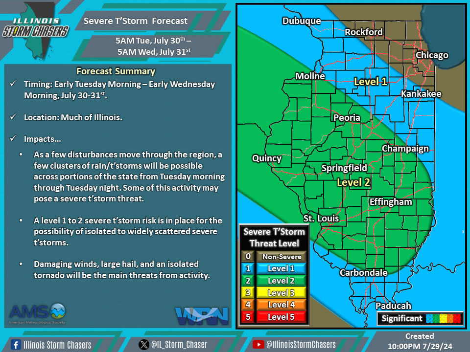
•Early Tuesday Morning – Early Wednesday Morning, July 30-31st: Much of Illinois.
•Early Wednesday Morning – Early Thursday Morning, July 31st-August 1st: Much of Illinois.
Impacts…
•A level 1 evere t’storm risk is in place across Southern Illinois from tonight through early Tuesday morning for the possibility of isolated severe t’storms. Damaging winds, large hail, and an isolated tornado will be the main threats from activity.
•A level 1 to 2 severe t’storm risk is in place across much of Illinois from early Tuesday morning through early Wednesday morning for the possibility of isolated to widely scattered severe t’storms. Damaging winds, large hail, and an isolated tornado will be the main threats from activity.
•A level 1 severe t’storm risk is in place across much of Illinois from early Wednesday morning through early Thursday morning for the possibility of isolated severe t’storms. Damaging winds, large hail, and an isolated tornado will be the main threats from activity.
Discussion…
•Clusters of rain/t’storms can be expected across the region and state on a daily/nightly basis during this period. Severe t’storms will be possible with some of this activity across specific outlooked areas during this timeframe.
•For tonight through early Tuesday morning, scattered showers and t’storms will continue to be likely across Southern Illinois. Environmental conditions will be supportive of a severe t’storm threat with some of this activity.
•For early Tuesday morning through early Wednesday morning, a few clusters of rain/t’storms will be possible across the state. Environmental conditions will be supportive of a severe t’storm threat with some of this activity across Northern Illinois.
•For early Wednesday morning through early Thursday morning, a few clusters of rain/t’storms will be possible across the state. Environmental conditions will be supportive of a severe t’storm threat with some of this activity across Northern Illinois.
•A severe t’storm threat will also exist Thursday through Friday. More specific information regarding the potential for these days is to come in future updates.


