
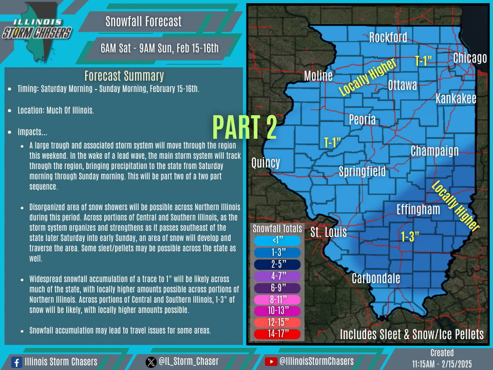
(11:15AM – Saturday, February 15th, 2025) Saturday morning update on a TWO PART storm system will continue to impact the state, through Sunday morning. PART 1, which impacted Northern and Central Illinois with wintry impacts from Friday afternoon through this morning, has now concluded. PART 2 will bring more wintry impacts to the state from this morning through Sunday morning, including the potential for accumulating snow.
…PART ONE…
•Part one has now concluded. Part one impacted Northern and Central Illinois with wintry impacts from Friday afternoon through this morning.
…PART TWO…
Timing…
•Saturday Morning – Sunday Morning, February 15-16th.
Location…
•Much Of Illinois.
Impacts…
•Widespread snowfall accumulation of a trace to 1″ will be likely across much of the state, with locally higher amounts possible across portions of Northern Illinois. Across portions of Central and Southern Illinois, 1-3″ of snow will be likely, with locally higher amounts possible.
•Freezing rain/ice accumulation of a glaze will be possible across the heart of the state.
•Snow/sleet/pellet/ice accumulation may lead to travel issues for some areas.
Discussion…
•As the main developing and strengthening storm system tracks through the region over the weekend, precipitation will traverse the state, with some snow and mixed precipitation expected across the state from this morning through Sunday morning. Disorganized area of snow showers will be likely across Northern Illinois during this period, possibly mixed with sleet, pellets, and freezing drizzle early on. Across Portions of Central and Southern Illinois, as the storm system organizes and strengthens as it passes southeast of the state late Saturday into early Sunday, precipitation will transition and an area of snow will develop and traverse the area. Some sleet/pellets/freezing drizzle may be possible as well.

