
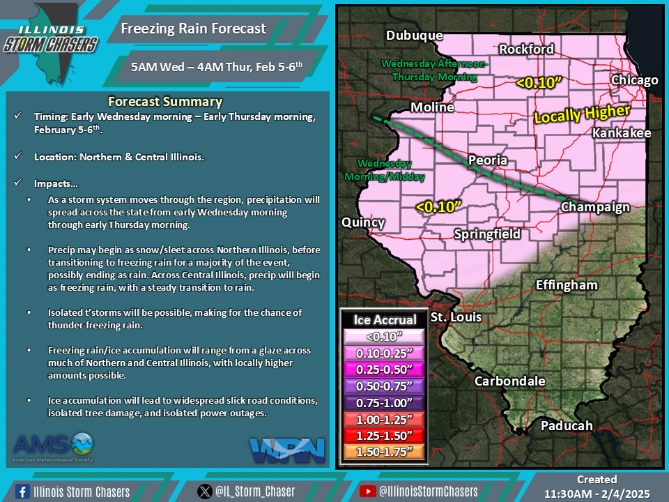
(11:30AM – Tuesday, February 4th, 2025) Tuesday morning update on a storm system that will through the region, bringing precipitation that will traverse a large portion of the state from early Wednesday morning through early Thursday morning. A wintry mix of precipitation will affect Northern and Central Illinois during this time.
Timing…
•Early Wednesday morning – Early Thursday morning, February 5-6th.
Location…
•Northern & Central Illinois.
Impacts…
•Freezing rain/ice accumulation will range from a glaze across much of Northern and Central Illinois, with locally higher amounts possible.
•Snow/sleet/ice pellet accumulation will range from a trace to a dusting across Northern Illinois.
•Isolated t’storms will be possible, making for the chance of thunder-freezing rain/sleet/ice pellets/snow.
•Ice accumulation will lead to widespread slick road conditions, isolated tree damage, and isolated power outages.
Update…
•With this update, the going forecast is on track, with little to no changes needed. However, we have introduced a snow/sleet/ice pellet accumulation forecast map, as a visual for the previous mention of these precipitation types.
Discussion…
•As a storm system moves through the region, precipitation will spread across the state from early Wednesday morning through early Thursday morning.
•Across Northern Illinois, precipitation will begin as a mix of snow/sleet/ice pellets/freezing rain Wednesday afternoon and evening, before transitioning to freezing rain with time for Wednesday night, and then possibly ending as rain by Thursday morning.
•Across Central Illinois, precipitation will begin as a period of freezing rain during the Wednesday morning/midday timeframe, before transitioning to rain.
•Across Southern Illinois, rain showers can be expected from Wednesday morning through Wednesday evening. No wintry precipitation is expected.

