
(11:30AM – Tuesday, April 2nd, 2024) Tuesday morning update on the storm system moving through the region that will bring accumulating snow and high winds to portions of the state from this afternoon through Thursday morning.
Update…
•With this update, we have shifted the greatest expected snowfall accumulations a bit west. This changes was made based on the latest weather guidance and the expectation that the storm system will occlude/wrap-up a bit further west.
•With this update, we have issued a high wind forecast for the Tuesday through Thursday period. Confidence has increased int he potential for wind gusts in excess of 40MPH, which prompts high wind forecast issuance.
Timing & Location…
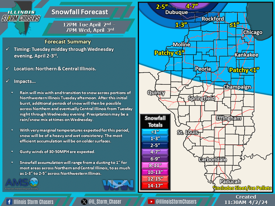
•Snow Event: Tuesday Midday – Wednesday Evening, April 2-3rd.
•High Wind Event: Tuesday Afternoon – Early Thursday Morning, April 2-4th.
Impacts…
•Rain will mix with and transition to snow across portions of Northwestern Illinois Tuesday afternoon. After this initial burst, additional periods of snow will then be possible across Northern and eventually Central Illinois from Tuesday night through Wednesday evening. Precipitation may be a rain/snow mix at times on Wednesday.
•With very marginal temperatures expected for this period, snow will be of a heavy and wet consistency. The most efficient accumulation will be on colder surfaces.
•Snowfall accumulation will range from a dusting to 1” for most areas across Northern and Central Illinois, to as much as 1-3” to 2-5” across Northwestern Illinois.
•A period of high winds is likely, with wind gusts ranging from 30-50MPH expected. The highest winds will be in the Wednesday morning through Wednesday evening timeframe.
•The high winds will have the potential to blow around light weight/loose items and cause minor tree damage.

