
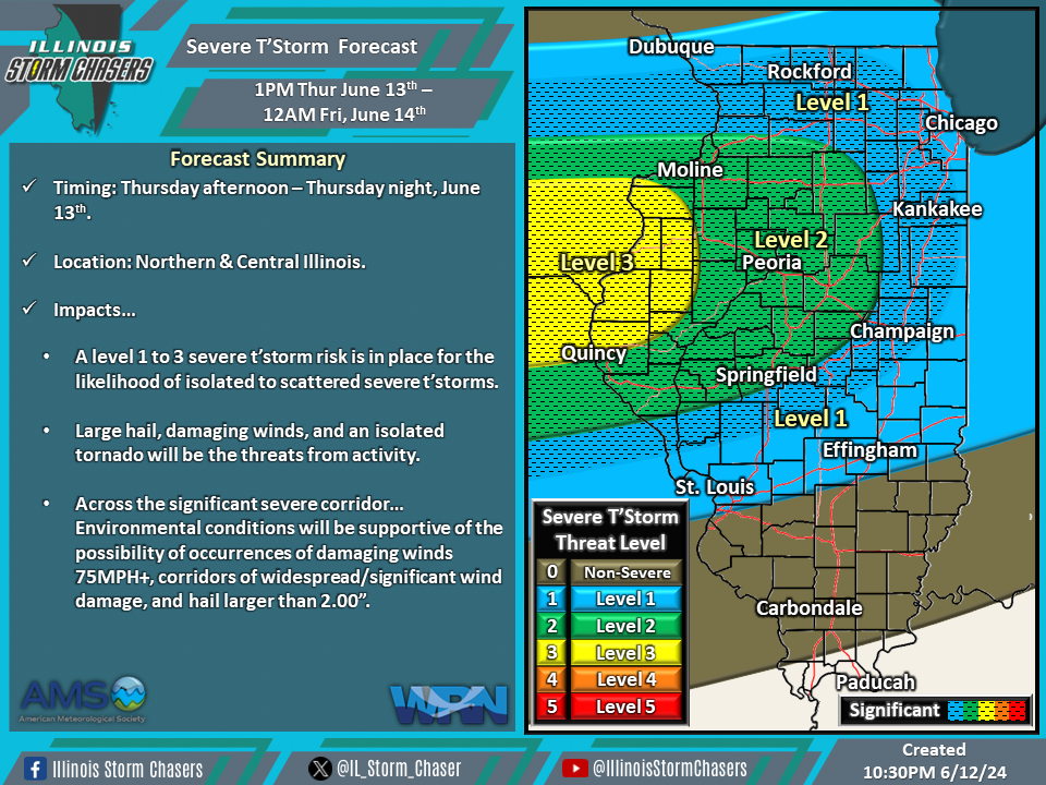
(10:30PM – Wednesday, June 12th, 2024) Wednesday night update on a storm system that will move through the region on Thursday, bringing a round of rain and t’storms to the state from Thursday afternoon through Thursday night. Severe t’storms will be likely with some of this activity across outlooked areas during this timeframe.
Update…
•With this update, on the severe t’storm forecast for Thursday/Thursday night, we have increased the severe t’storm threat level across portions of the state.
Timing…
•Thursday Afternoon – Thursday Night, June 13th.
Location…
•Northern & Central Illinois.
Impacts…
•A level 1 to 3 severe t’storm risk is in place across Northern and Central Illinois from Thursday afternoon through Thursday night for the likelihood of isolated to scattered severe t’storms. Large hail, damaging winds, and an isolated tornado will be the threats from activity. Across the significant severe corridor… Environmental conditions will be supportive of the possibility of occurrences of damaging winds 75MPH+, corridors of widespread/significant wind damage, and hail larger than 2.00”.
Discussion…
•As a cold front slides southward across the state, a round of showers and t’storms will develop across portions of Southern Wisconsin, Iowa, and Northern Illinois on Thursday afternoon. This activity will then track southeastward across portions of Northern and Central Illinois from Thursday afternoon through Thursday night. It should be noted that there is a decent amount of disagreement among the weather model guidance in terms of placement and speed of the passing cold front. This will play a significant role in determining where severe t’storm development will first occur, which in turn will determine the exact location of where the better severe t’storm threat will occur. The hope is that better weather model guidance agreement will have occurred by Thursday morning, along with the ability to watch real-time observations coming into play. An environment will be in place that will be supportive of severe t’storms; thus, some of the activity during this timeframe will likely be severe across the outlooked areas. Forecast soundings suggest large hail and damaging winds will be the greatest threats from activity.
