
(11:45AM – Saturday, December 27th, 2025) A potent storm system will bring severe t’storm chances, high winds, and snow to the state between Sunday and Monday…
❗Update…
With this update, no changes were needed to ongoing forecasts.
⏰Timing…
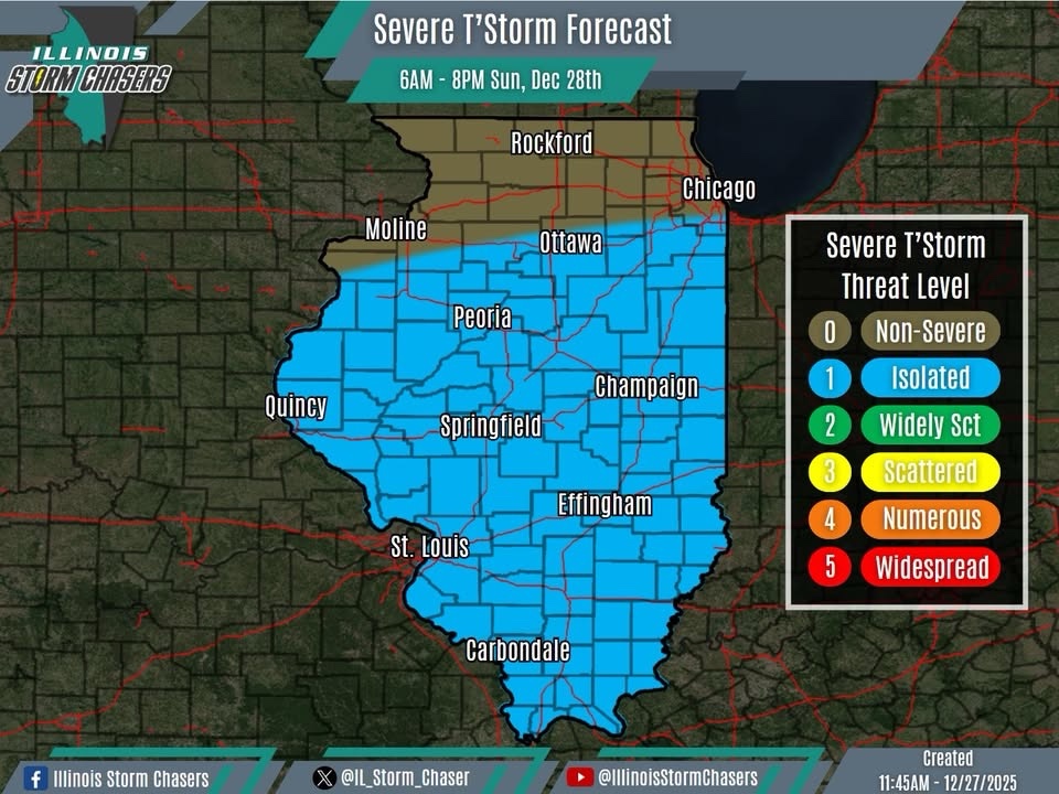
•Severe T’Storm Threat: Sunday Morning – Sunday Evening, December 28th.
•High Winds: Sunday Midday – Monday Afternoon, December 28-29th.
•Snow: Sunday Evening – Monday Midday, December 28-29th.
📍Location…
•Severe T’Storm Threat: Central & Southern Illinois.
•High Winds: All of Illinois.
•Snow: Northern Illinois.
⚡️💨❄️Hazards…
•A level 1 severe t’storm threat is in place across all of Central and Southern Illinois during the specified timeframe, for the threat of isolated severe t’storms. Damaging winds, hail and a tornado or two will be the main threats with activity.
•Peak high wind gusts of 40-50MPH will be likely across the state during the specified timeframe. Winds will be westerly to northwesterly. The high winds will have the potential to blow around light-weight/loose items and may cause isolated tree damage.
•Snowfall accumulation of a dusting to 1″ will be possible across portions of Northern Illinois during the specified timeframe.
✔️Summary…
•As a potent storm system moves through the region, impactful weather is likely across the state from Sunday on into Monday.
•Widespread rain and t’storm activity will traverse the state on Sunday, as a warm front lifts across the state and then a cold front quickly sweeps across the state. Of focus will be Central and Southern Illinois. Across this corridor, severe t’storms may be possible with some of this activity during the specified timeframe.
•Strong cold air advection will occur across the state in the wake of the cold frontal passage, on the backside of the storm system. With a strong low-level jet and adequate atmospheric mixing, a period of high synoptic winds will be likely across the state during the specified timeframe.
•As much colder air quickly moves in in the backside of the storm system, snow/snow showers will wrap around and into portions of Northern Illinois during the specified timeframe.


