
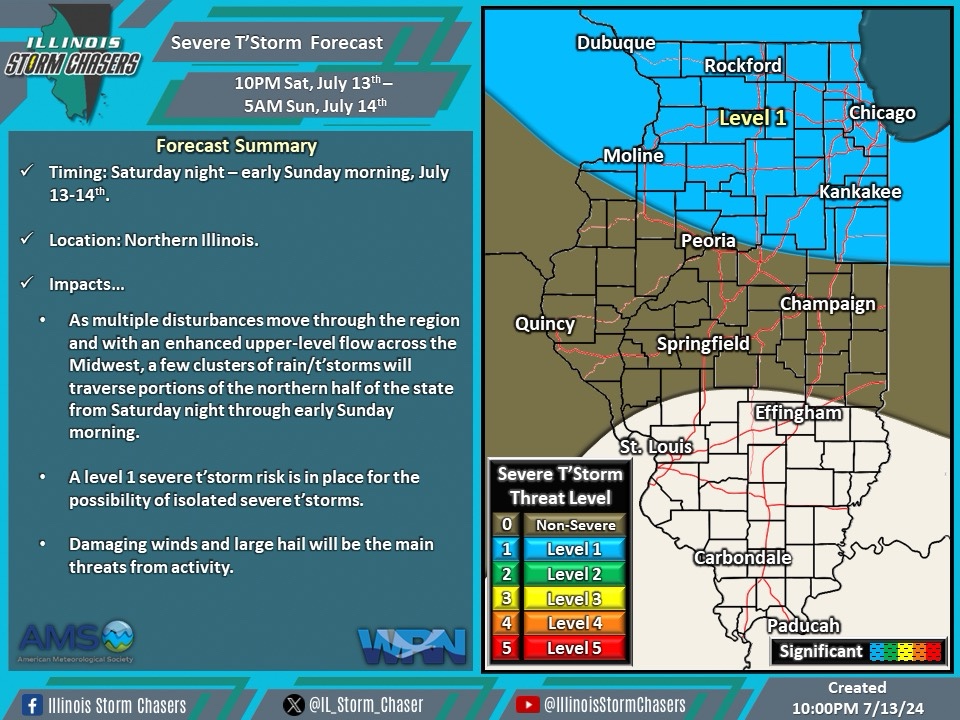
(10:30PM – Saturday, July 13th, 2024) Saturday night update on a “Ring of Fire” pattern in place, with multiple disturbances that will move through the region with an enhanced upper level flow in place atop ridging across the Inter-Mountain West and Central U.S. Clusters of rain/t’storms will continue to be likely on a daily/nightly basis across portions of the region and state during this period. Severe t’storms will be likely with some of this activity across specific outlooked areas during this timeframe.
Update…
•With this update on the severe t’storm forecast for tonight, little to no changes were needed. The going forecast is on track.
•With this update on the severe t’storm forecast for Sunday/Sunday night, little to no changes were needed. The going forecast is on track.
•With this update, we have issued our first severe t’storm forecast for the Monday/Monday night period.
Timing & Location…
•Tonight – Early Sunday Morning, July 13-14th: Northern Illinois.
•Early Sunday Morning – Early Monday Morning, July 14-15th: Northern and Central Illinois.
•Early Monday Morning – Early Tuesday Morning, July 15-16th: Northern and Central Illinois.
Impacts…
•A level 1 severe t’storm risk is in place across Northern Illinois from tonight through early Sunday morning for the likelihood of isolated severe t’storms. Damaging winds and large hail will be the main threats from activity.
•A level 1 severe t’storm risk is in place across Northern and Central Illinois from early Sunday morning through early Monday morning for the likelihood of isolated severe t’storms. Damaging winds and large hail will be the main threats from activity.
•A level 1 to 2 severe t’storm risk is in place across Northern and Central Illinois from early Monday morning through early Tuesday morning for the likelihood of isolated to widely scattered severe t’storms. Damaging winds, large hail, and an isolated tornado will be the main threats from activity.
Discussion…
•Clusters of rain/t’storms will continue to be likely across the region and state on a daily/nightly basis during this period. Severe t’storms will be likely with some of this activity across specific outlooked areas during this timeframe.
•For tonight through early Sunday morning, additional clusters of rain/t’storms will be likely across portions of the northern half of the state. Environmental conditions will be supportive of some severe t’storm threat with this activity across Northern Illinois.
•For early Sunday morning through early Monday morning, a few clusters of rain/t’storms will be likely across portions of Northern and Central Illinois. Environmental conditions will be supportive of a severe t’storm threat with some of this activity.
•For early Monday morning through early Tuesday morning, a few clusters of rain/t’storms will be likely across portions of the state. Environmental conditions will be supportive of a severe t’storm threat with some of this activity.


