
(11:30AM – Friday, January 3rd, 2025) A winter storm will move through the region from late Saturday through late Monday, bringing multiple precipitation types to the state, including accumulating snow, sleet and ice. Significant snowfall and ice accumulations may be possible.
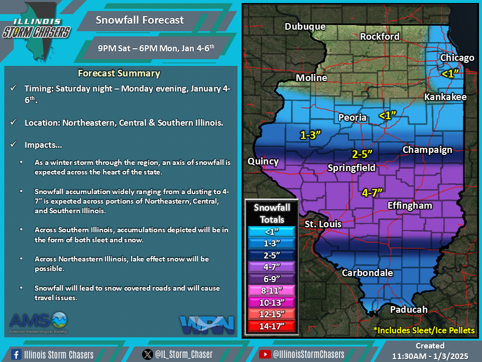
Timing…
•Saturday night – Monday evening, January 4-6th.
Location…
•Much of Illinois.
Impacts…
•Snowfall accumulation widely ranging from a dusting to 4-7” is expected across portions of Northeastern, Central, and Southern Illinois.
•Freezing rain/ice accumulation will range from a glaze to 0.25-0.50” across portions of Southern Illinois.
•Snowfall and ice accumulation will lead to snow and ice covered roads, leading to travel issues.
•Some power outages and tree damage will be possible across Southern Illinois, due to expected ice accumulation.
•Moderate to heavy snow will be likely at times between Sunday morning and Monday morning across the heart of Illinois, where snow will be favored.
•Wind gusts of 25-35MPH will be possible across Southern Illinois from midday Sunday through midday Monday.
Discussion…
•As a winter storm moves through the region, multiple types of precipitation will accompany it. Snow, sleet, and freezing rain will be the precipitation types most favored across affected areas for this event, with significant accumulations of each precipitation type being possible.
•It should be noted that there continue to be storm system track, storm system strength, precipitation location, and precipitation accumulation difference within weather guidance. Thus, with this being the initial forecast, some changes will be possible in future forecast updates.
•Across Central Illinois, a majority of precipitation will fall as snow, as temperatures from the surface up through the atmospheric column will stay cold enough for an all snow event.
•Across Southern Illinois, with warm air advection on the frontside of the winter storm, dynamic cooling during the event, and cold air advection on the backside of the storm system, multiple precipitation types are likely. Precipitation may initially start as snow/sleet, before transitioning to freezing rain and sleet will be favor during the middle 2/4th of the event, before ending as snow for the final 1/4th of the event.
•Across Northeastern Illinois, lake effect snow will be possible. The significance of this potential is still in question, thus, we will opt for the lower end of potential as of this forecast.

