
(11:45PM – Monday, March 9th, 2026) Severe t’storm threat expected across the state from Tuesday afternoon through Wednesday midday…
⚠️Update…
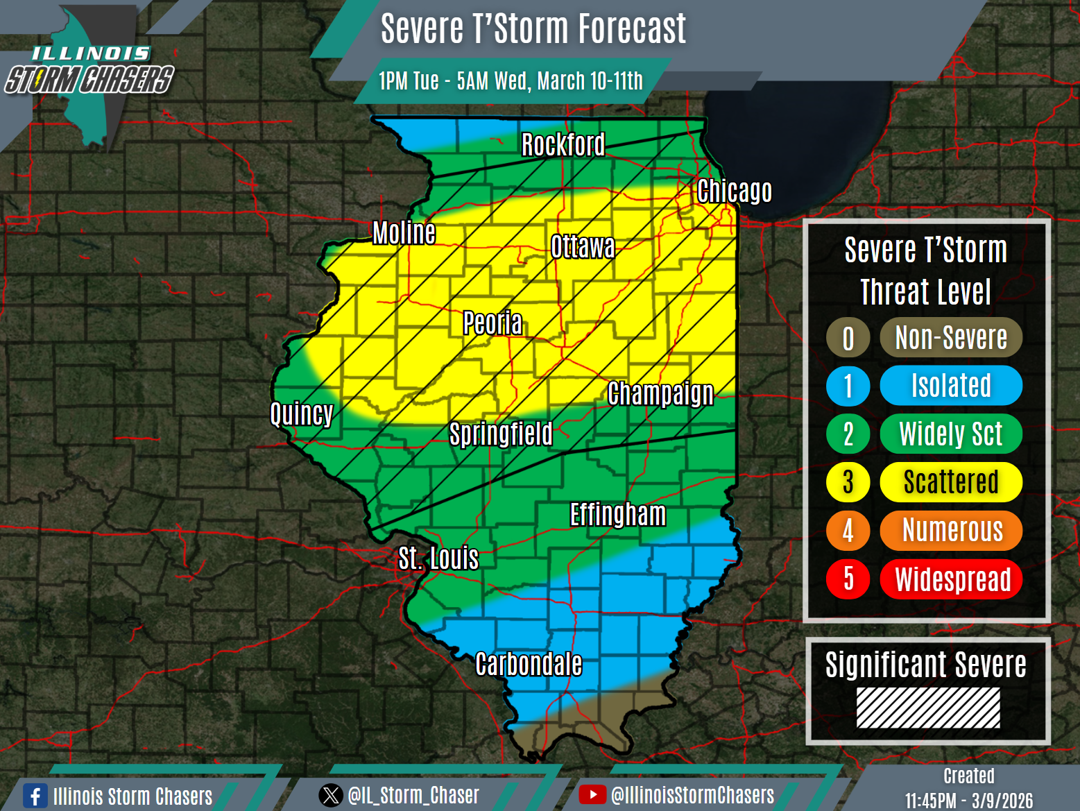
•With this update, we have slightly adjusted positioning of severe t’storm probabilities portions of Northern and Central Illinois. This change was made on the latest weather guidance and trends.
⏰📍Timing & Location…
•Tuesday Afternoon – Early Wednesday Morning, March 10-11th: Much of Illinois.
•Wednesday Morning – Wednesday Midday, March 11th: Southern Illinois.
⚡️Hazards…
•A level 1 to 3 severe t’storm threat is in place across much of the state from Tuesday afternoon through Wednesday morning, for the threat of isolated to scattered severe t’storms. All modes of severe weather will be possible, including large hail, damaging winds and some tornadoes. Environmental conditions will be favorable for some significant severe t’storms across the hatched outlook area, with activity capable of 2.00″+ hail and strong tornadoes.
•A level 1 severe t’storm threat is in place across Southern Illinois from Wednesday morning through Wednesday midday, for the threat of isolated severe t’storms. Damaging winds and hail will be the main threats.
✔️Summary…
•Tuesday Afternoon – Early Wednesday Morning… Scattered showers and t’storms are expected to develop on Tuesday afternoon across portions of Northern Illinois, in the vicinity of a warm front expected set up in the area. This activity will track eastward across portions of Northern and Central Illinois through the evening. For areas along and south of the warm front, roughly from around I-80 on southward, surface based severe t’storm will be likely, posing a risk of all modes of severe weather. For areas north of the warm front, generally areas north of I-80 to the Illinois /Wisconsin border, elevated severe t’storm activity will be possible, with large hail being the main threat. In addition to this activity, scattered showers and t’storms will also develop ahead of an advancing cold font, from Western Illinois down into Missouri and the Southern Plains later Tuesday afternoon and evening. This activity will track northeast/east, across a good portion of the state from later Tuesday evening through Wednesday morning. Hail and damaging winds will be the main threat with this activity.
•Wednesday Morning-Wednesday Midday… Remnant areas of shower and t’storm activity will be roaming portions of Central and Southern Illinois on Wednesday morning. Some of this activity may re-strengthen, with some new development possible as well. This activity will track northeast/east across especially Southern Illinois, from Wednesday morning through midday Wednesday. An isolated severe t’storm threat will be possible with this activity.

